Ice is already causing problems to the north and west of Nashville. And rain for most of Middle Tennessee is expected to start freezing by midnight.
Meteorologists with the National Weather Service say the transition will start around 7 p.m. in Nashville. Communities on a line from Franklin to Cookeville may not get freezing rain until early Friday morning. And from Columbia and farther south could escape ice altogether.
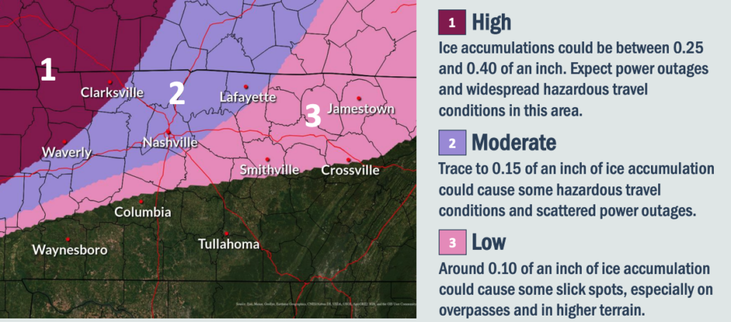
For those already experiencing ice, more than a quarter inch could coat trees and utility lines. The weather service warns residents in the Clarksville area to expect power outages and widespread hazardous travel.
 courtesy National Weather Service
 Clarksville is expected to get the most ice, with more than .25 inches. But there could still be slick spots as far south as Columbia.
The Clarksville-Montgomery County School System dismissed early in an effort to avoid the worst of the ice. The American Red Cross called off blood drives. And Western Kentucky University in Bowling Green canceled evening classes.
Nashville has closed its COVID testing and vaccination drive-thru centers for Friday, though the decision was as much about the cold as potentially hazardous driving conditions.
A flood watch is also in effect though forecasters say they are not expecting much flash flooding. But rivers may remain elevated for several days after the precipitation clears out Friday.
Sleet continuing to fall in Southwest Obion County. #tnwx @NWSMemphis @NC5_LelanStatom @NbergWX @wxShaley pic.twitter.com/j0IRmjTrfc
— Robin Cude (@rcude93) February 3, 2022

