Tennessee lawmakers are considering legislation this year that would require public access to maps of floods and landslides across the state.
There are two bills with the same intent: the Tennessee Department of Environment and Conservation would collect and publish data on floods and landslides.
More: Landslides are a growing threat in Nashville. Blame climate change and developers.
Sen. Ed Jackson, R-Jackson and Rep. Rusty Grills, R-Newbern filed one version of the bill, which also specifies that the department should include info on the geographic location, duration and severity of the two hazards. Sen. Heidi Campbell, D-Nashville and Rep. Jason Powell, D-Nashville filed a similar bill one week earlier in January.
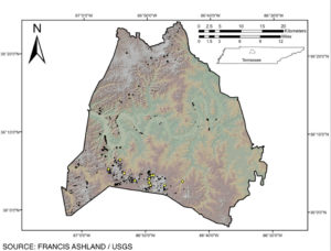
 Courtesy Francis Ashland/USGS
 The black dots represent May 2010 landslides, and the yellow dots represent some of the March 1975 landslides. The map was created by a U.S. Geological Survey scientist.
Powell introduced a similar bill last year that also included funding for a mesonet, a statewide weather monitoring network, but the funding was removed from this year’s bill. In November, the Tennessee Department of Military requested funding directly from Gov. Bill Lee for a mesonet but the department was not awarded the funds.
Climate context
Risks for both floods and landslides have become greater in Tennessee in recent decades and will continue to increase with additional planetary warming.
Climate change driven by fossil fuels, deforestation and agriculture has intensified rainstorms, which can lead to more destructive flooding and then landslides. In 2010, for example, Nashville had at least 560 landslides after a two-day, 13-inch rainfall.
To create better climate models for precipitation, flooding and landslides, scientists have said the state needs a mesonet, which also helps with forecasting precipitation and other extreme weather.

