
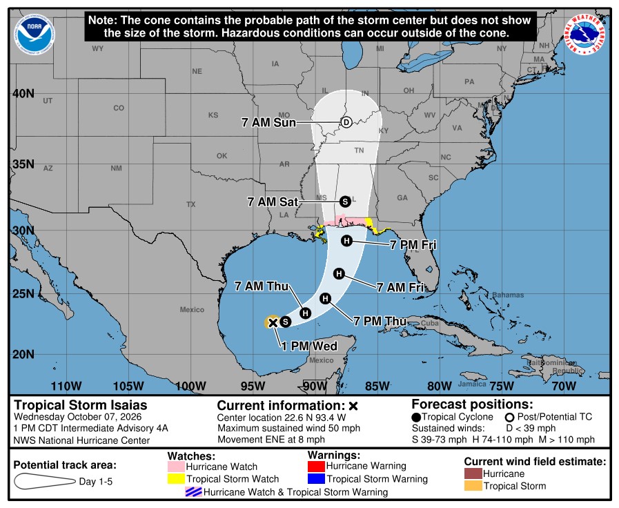
The first hurricane of the Atlantic season could stir up two severe weather threats in Middle Tennessee this weekend.
Tropical Storm Isaias formed this week off eastern Mexico in record warm waters. It could reach hurricane strength before hitting the U.S. Gulf Coast between New Orleans and Tallahassee later this week.
As the storm travels north, tropical moisture may bring a risk of heavy rainfall across Tennessee by Saturday.
The National Weather Service forecasts one to three inches of rain and 30-mile-per-hour winds in Middle Tennessee. That forecast can change quickly, however, and the agency recommends that folks watch for updates this weekend and prepare to change plans if traveling. If the forecast shifts toward heavier rainfall, the resulting flooding could create additional risks for landslides in hilly areas.
More: High demand is straining Nashville’s water system. Metro asks you to limit sprinklers | WPLN News
The rain could also bring some relief to Middle Tennessee amid what has quickly become another widespread drought across the state. Nashville and parts of the region were facing “severe” drought levels last week, according to the latest U.S. Drought Monitor. Nashville had only just recovered from drought in early August following the city’s driest eight-month stretch since 2007.
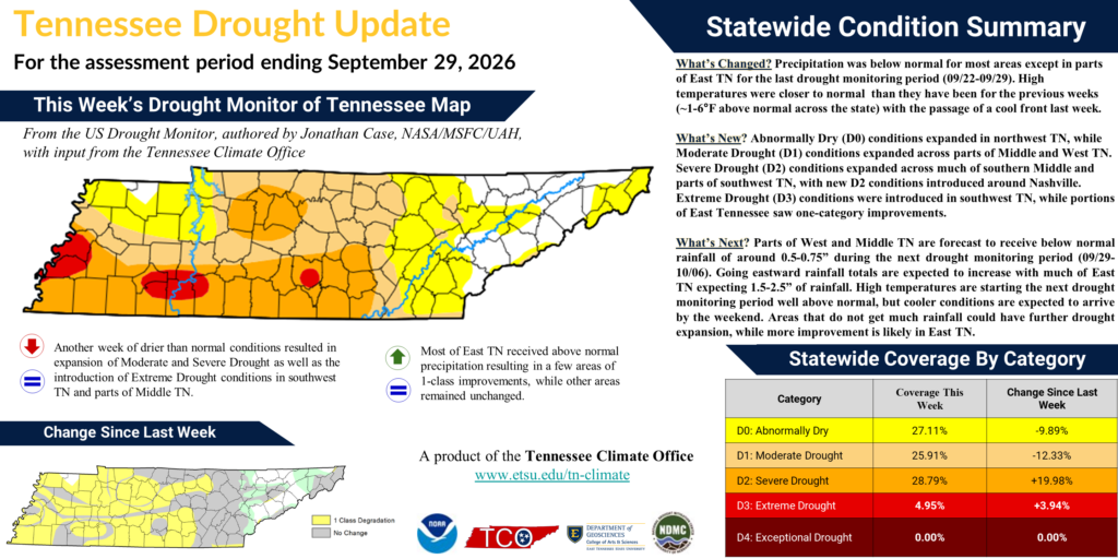 Courtesy Tennessee Climate Office
 Middle Tennessee reached moderate to severe drought levels by the last week in September, according to the U.S. Drought Monitor.
Isaias also carries a higher-than-normal risk for tornadoes spinning up as it travels across the Southeast. The tropical storm will pull dry air behind it that may clash with a zone of warm, humid air near the ground in Tennessee, creating thunderstorm cells. Those cells could acquire rotation from Isaias’s spinning wind. The tornado risk is currently low in Tennessee and highest in Alabama, Georgia and Florida.
The storm is forming amid unseasonable warmth. Swaths of ocean in the Gulf of Mexico are record warm for this time of year, according to the National Oceanic and Atmospheric Administration. Planetary warming from the burning of fossil fuels and deforestation has made this ocean warming several hundred times more likely, according to Climate Central’s Climate Shift Index on Oct. 6.
Isaias may become the latest hurricane to form, at least by reliable records, during the Atlantic hurricane season, which has included eight other named tropical storms this year. Experts point to a very strong El Niño for the weakened Atlantic activity this year — though the climate pattern can increase activity in the North Pacific.
The nation will face another hurricane risk this week. Hurricane Rachel is expected to make landfall in Mexico later this weekend and could potentially impact California. Two tropical systems threatening both sides of the U.S. is fairly rare, with a notable example of Hurricanes Ida and Nora in 2021.

 On Air - 90.3 WPLN-FM