

How long have Tennessee’s political maps been gerrymandered?
The current special session may be the fastest Tennessee’s political map has ever been redrawn; but there’s a history of changing the lines for party gain. Plus, the local news for May 7, 2026, and Key Changes looks at comedy in country music.
More: Redistricting live blog
Below is a partial transcript of the episode:

It’s May 7, 2026. This week, Tennessee’s legislature has been back at work in a special session, called to quickly redraw Congressional district lines, fast-tracking a process that normally takes … well, substantially longer. The speed run is underway because the Supreme Court issued a ruling last week that negates the part of the Voting Rights Act that was the only reason Memphis hadn’t already been carved into multiple districts to benefit Republicans.
Coming up in the newscast portion of this episode, we’ll have the latest developments from the statehouse. But first, I thought I’d take a step back and try to put this in perspective by looking at how redistricting has previously played out in Tennessee.
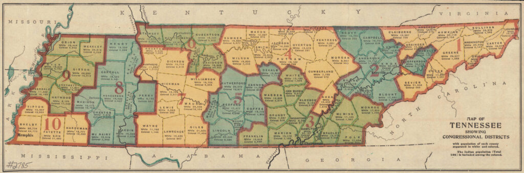
Back at the very start of statehood in 1796, there were just two big districts: one for East Tennessee, which was the most populous area at the time, and one for everything else. A few years later, in 1803, the map was redrawn to be three districts that basically followed what we now consider the state’s grand divisions: East, Middle and West.
Over the next little while, swift changes to the Congressional map show just how many people were moving into the state, as the number of districts increased to six, then eight, up to 13. The state government was reorganized with a new constitution and new district maps in the 1840s and again after the Civil War. The number of districts crept up to 10 by the end of the 19th century.
There was a little fluctuation up and down, but something to note about all of the many changes up to that point was that the Congressional district lines were always drawn in a way that no counties were split up. And generally speaking, if you lay those boundary lines over a map that showed the state’s geological features, like mountains, plateaus and rivers, the lines would make sense. The main thing the General Assembly was concerned with as it sorted out the district lines was getting a decent population balance between the districts – theoretically, anyway.
To be fair, for a lot of that time, Tennessee was nearly a one-party state, so there wasn’t that much concern for carving out strongholds for one political group or another.
From 1901 to 1961, Tennessee didn’t really bother with redrawing the Congressional district lines. State law did say the map should be revisited after every national census, but the General Assembly pretty much just left things alone. But the population was shifting and growing. And eventually, a lawsuit was filed accusing the state of depriving people of appropriate representation.
The case, called Baker v. Carr, went all the way to the U.S. Supreme Court. The justices ruled that the state was “guilty of a clear violation” that conflicted with both the Tennessee Constitution and the 14th Amendment to the U.S. Constitution. Now, this case got deep into the weeds of the disparate populations of various counties, and how drawing Congressional district lines that keep counties together ended up giving some more rural counties more voting power than others with more people – a problem that was only exacerbated and exaggerated by leaving the district lines the same while people kept moving around.
The Supreme Court decision ultimately meant that Tennessee’s lines had to be redrawn, and they had to be mapped out using a new philosophy that was careful to protect the concept of each person’s vote being equal to anyone else’s.
It also coincided with the start of the rise of the GOP in Tennessee. Which meant two-party politics were starting to gear up in a way nobody living at that time had ever seen before in the state. Things were starting to get competitive.
Put those two factors together, and you get the start of, shall we say, creative Congressional map-making in Tennessee. I’m hesitant to pick a redistricting and say “here’s where the gerrymandering begins,” because that stagnant map that was in place for so long did need significant fixing, and one-person-one-vote is an important concept that doesn’t always map out cleanly.
But right away, Memphis was split into three districts. There was one tiny one, just in Shelby County, that held an area of highly concentrated population. It went Republican in that first election. The rest of Memphis was split between two larger districts that basically split up the rest of West Tennessee. Both of those were held by Democrats.
Middle and East Tennessee were also split into three districts each. In our part of the state, Davidson County was a district of its own, with the rest of the Midstate divided right down the geographical center. All three were represented by Democrats. East Tennessee was pretty much cut into three similarly-sized chunks. And Republicans held those seats.
In the 70s, district lines started to wander as the Democrats controlling the state legislature tried to block Republicans from at least one of those seats in Congress. They didn’t respect those lines between the grand divisions anymore. The central Memphis district got bigger, but portions of Middle Tennessee were added to the other western districts. Clarksville and Cheatham County were put into the same district with Nashville.
In the 80s, the lines between districts get more zig-zaggy. In the 90s, We get our first glimpse of districts that get long and skinny in the middle to connect larger areas at either end. The most egregious example was the 4th, which included both Hardin County, which touches Alabama and Mississippi and, many miles away, Campbell County, which is on the Kentucky line and comes just shy of touching Virginia.
The one thing you can say for that district map is that it keeps counties with similar concerns together. So people on either end of that giant, misshapen version of the 4th District were mostly concerned with agriculture and the issues facing rural communities. That legislator’s constituent service staff likely fielded similar requests from across the district. But they did have to cover an absurdly shaped and absurdly large geographic zone.
Through all of this time, as election cycles churn, the map keeps getting a little more red and a little less blue.
The first new map of the 21st century straightened out most of those lines. But a successful attempt to group Republican strongholds in Middle and West Tennessee into one district so Democrats could have a better chance in the rest created what has to be one of the most strangely-shaped districts of all time. It’s certainly the most odd we’ve ever had in Tennessee.
Imagine a fan with three blades. It’s a plastic fan that was exposed to a lot of heat, and those blades melted into weird, gnarly curled shapes, but you can still see that it’s three blades, points touching at the middle, and extending out opposite of each other. Except the far end of one of those blades is attached to a much larger blob with no definable shape.
And that, my friends, is what shape Tennessee’s 7th Congressional District used to be.
There was also the odd matter of the way that the 6th District kind of cupped around Davidson County like a sideways V, and then the 4th District cupped around the 6th. And over in East Tennessee, the 3rd District did still vaguely resemble a dumbbell.
By 2010, all of those oddly shaped districts were held by Republicans. The only Democratic seats left were the ones in Nashville and Memphis. And by this point, the GOP held a majority in the statehouse, giving it the largest say in how Congressional districting maps would be drawn.
The big move after the 2020 Census was to slice up Nashville for the first time ever. And now, just a few years later, the same is being done to Memphis.
Credits:
This is a production of Nashville Public Radio.
Host/producer: Nina Cardona
Editor: LaTonya Turner
Additional support: Mack Linebaugh, Tony Gonzalez, Megan Jones and the staff of WPLN and WNXP
 On Air - 90.3 WPLN-FM